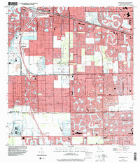
1994 Map of Cooper City
USGS Topo · Published 2000About this map
Cooper City and its surrounding communities are mapped here during a period of rapid development in Broward County, where intricate canal networks like the New River Canal and Snake Creek Canal define the suburban layout. The landscape is characterized by a high concentration of recreational and institutional spaces, including numerous golf courses and the sprawling grounds of the South Florida State Hospital in the southeast. Cultural and community hubs are well-represented by sites such as Camp Seminole (BSA), Holy Sacrament Ch, and St Gregory Sch. This map illustrates how drainage engineering and corporate boundaries, such as the Davie Corporate Boundary, shaped the expansion of Plantation, Sunrise, and Pembroke Pines into former wetlands, creating the distinctive residential patterns of modern South Florida.
Find a feature on this map
38 named features on this map. Tap any name to fly to it.
Don’t see what you’re looking for? This feature index may not catch every label — zoom into the map to look around manually.
Map Details
Editions of this 1994 Cooper City Map
This is the sole edition of this map. No revisions or reprints were ever made.
Other maps of this area

1945 · Fort Lauderdale North
USGS Topo · 1:24,000

1947 · North Miami
USGS Topo · 1:24,000

1949 · Opalocka
USGS Topo · 1:24,000

1949 · Fort Lauderdale North
USGS Topo · 1:24,000

1949 · Fort Lauderdale South
USGS Topo · 1:24,000

1950 · North Miami
USGS Topo · 1:24,000

1956 · Miami
USGS Topo · 1:250,000

1956 · West Palm Beach
USGS Topo · 1:250,000

1957 · West Palm Beach
USGS Topo · 1:250,000

1958 · West Palm Beach
USGS Topo · 1:250,000