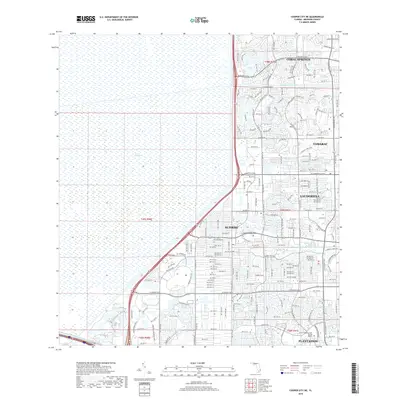
2018 Map of Cooper City NE
USGS Topo · Published 2018About this map
The Everglades dominates the western half of this landscape, meeting the abrupt eastern edge of Broward County's urban expansion. This sharp division between the conservation area and the burgeoning residential developments of Sunrise and Tamarac illustrates the late 20th-century push toward the state's interior. A network of managed waterways, including the North New River Canal and the Middle River Canal, facilitates drainage and boundary definition for these communities. The street grid is dense with modern planning, featuring major thoroughfares like the American Expressway and Sunset Strip that connect suburban clusters. Educational and corporate presence is noted at the Univ of Phoenix-South Florida Campus in Plantation, reflecting the transition of the region into a professional and residential hub at the edge of the wetlands.
Find a feature on this map
28 named features on this map. Tap any name to fly to it.
Don’t see what you’re looking for? This feature index may not catch every label — zoom into the map to look around manually.
Map Details
Editions of this 2018 Cooper City NE Map
This is the sole edition of this map. No revisions or reprints were ever made.
Other maps of this area

1945 · Fort Lauderdale North
USGS Topo · 1:24,000

1946 · West Dixie Bend
USGS Topo · 1:24,000

1949 · Fort Lauderdale North
USGS Topo · 1:24,000

1949 · West Dixie Bend
USGS Topo · 1:24,000

1949 · Fort Lauderdale South
USGS Topo · 1:24,000

1956 · West Palm Beach
USGS Topo · 1:250,000

1957 · West Palm Beach
USGS Topo · 1:250,000

1958 · West Palm Beach
USGS Topo · 1:250,000
1962 · Fort Lauderdale North
USGS Topo · 1:24,000
1962 · West Dixie Bend
USGS Topo · 1:24,000