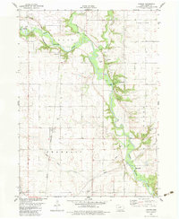
1982 Map of Cooper
USGS Topo · Published 1983About this map
The North Raccoon River carves a deep, wooded valley through this agricultural landscape in Greene County, Iowa, creating a sharp contrast with the surrounding gridded farmland. This early 1980s topography highlights the Chicago and North Western rail line as it cuts south through the township of Franklin, passing directly through the settlement of Cooper. The river corridor serves as a hub for local recreation and preservation, featuring Henderson County Park, Squirrel Hollow County Park, and the Rippey State Access Area.
Find a feature on this map
27 named features on this map. Tap any name to fly to it.
Don’t see what you’re looking for? This feature index may not catch every label — zoom into the map to look around manually.
Map Details
Editions of this 1982 Cooper Map
This is the sole edition of this map. No revisions or reprints were ever made.
Other maps of this area

1950 · Perry
USGS Topo · 1:62,500

1951 · Perry
USGS Topo · 1:62,500

1951 · Ogden
USGS Topo · 1:62,500

1954 · Bagley
USGS Topo · 1:62,500

1954 · Omaha
USGS Topo · 1:250,000

1954 · Fort Dodge
USGS Topo · 1:250,000

1957 · Omaha
USGS Topo · 1:250,000

1957 · Fort Dodge
USGS Topo · 1:250,000

1958 · Omaha
USGS Topo · 1:250,000

1958 · Fort Dodge
USGS Topo · 1:250,000
Featured Places
- Jefferson, Grant Township
- Junction Township, IA
- Washington Township, IA
- Franklin Township, IA
- Grant Township, IA