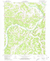
1981 Map of Cooper Hill
USGS Topo · Published 1981About this map
Gasconade River winds through this central Missouri landscape, shaping the development of the riverfront and interior settlements. The river is punctuated by prominent landforms such as Massie Island and Miller Island, while the surrounding terrain is defined by elevated ridges like Pointers Ridge and Nixon Ridge. Local centers of community life are anchored by rural institutions, including the College Hill Ch and Evangel St Paul Ch, alongside numerous family-named burial grounds like Leach Cem and Cox-Cooper Cem. The transport network of the early 1980s reveals a reliance on winding local roads connecting the hamlets of Useful, Freedom, and Ryors. Evidence of local industry appears at the Quarry near Compton Hill, while natural springs like Hollenback Spring and Little Bacon Spring dot the hollows, marking the area's geological character.
Find a feature on this map
67 named features on this map. Tap any name to fly to it.
Don’t see what you’re looking for? This feature index may not catch every label — zoom into the map to look around manually.
Map Details
Editions of this 1981 Cooper Hill Map
This is the sole edition of this map. No revisions or reprints were ever made.
Other maps of this area

1890 · Fulton
USGS Topo · 1:125,000

1934 · Linn
USGS Topo · 1:48,000

1934 · Bland
USGS Topo · 1:62,500

1935 · Morrison
USGS Topo · 1:48,000

1937 · Bland
USGS Topo · 1:62,500

1942 · Linn
USGS Topo · 1:62,500

1942 · Morrison
USGS Topo · 1:62,500

1945 · Mokane
USGS Topo · 1:62,500

1945 · Morrison
USGS Topo · 1:62,500

1945 · Linn
USGS Topo · 1:62,500