
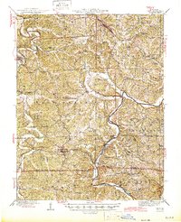
1945 Map of Linn
USGS Topo · Published 1945About this map
The Gasconade River winds through the eastern portion of this mid-century landscape, carving deep valleys and providing natural crossings like Daggetts Ford and Hoops Ford. This Osage County region is defined by a dense network of small rural schools such as Reichel Sch, Indian Creek Sch, and Potts Sch, serving the scattered settlements of Linn, Westphalia, and Rich Fountain.
Find a feature on this map
75 named features on this map. Tap any name to fly to it.
Don’t see what you’re looking for? This feature index may not catch every label — zoom into the map to look around manually.
Map Details
Editions of this 1945 Linn Map
2 editions found
Other maps of this area

1886 · Jefferson City
USGS Topo · 1:125,000

1888 · Tuscumbia
USGS Topo · 1:125,000

1890 · Fulton
USGS Topo · 1:125,000

1894 · Tuscumbia
USGS Topo · 1:125,000

1894 · Jefferson City
USGS Topo · 1:125,000

1934 · Linn
USGS Topo · 1:48,000

1934 · Bland
USGS Topo · 1:62,500

1934 · Redbird
USGS Topo · 1:62,500

1935 · Morrison
USGS Topo · 1:48,000

1937 · Bland
USGS Topo · 1:62,500