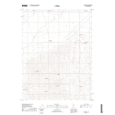
2018 Map of Cooper Peak
USGS Topo · Published 2018About this map
Roberts Mountains dominate this high-desert landscape in central Nevada, rising to the prominent summit of Cooper Peak. The terrain is defined by a series of deep drainage systems, including Pete Hanson Canyon and Gabel Canyon, which channel seasonal water from the heights down toward the broad Denay Valley in the north. The map reveals a network of vital water sources in this arid environment, such as Lower Dry Creek Spring and Upper Dry Creek Spring, which have historically been essential for livestock and travelers. While modern access is indicated by Tonkin Rd, the area remains characterized by its complex topography and numerous named drainages like Niel Cr and Pete Hanson Cr. This 2018 survey provides an exact record of the Township and Range boundaries across the mountainous interior of Eureka County.
Find a feature on this map
24 named features on this map. Tap any name to fly to it.
Don’t see what you’re looking for? This feature index may not catch every label — zoom into the map to look around manually.
Map Details
Editions of this 2018 Cooper Peak Map
This is the sole edition of this map. No revisions or reprints were ever made.
Other maps of this area

1926 · Roberts Mountains
USGS Topo · 1:250,000

1929 · Roberts Mountains
USGS Topo · 1:250,000

1937 · Mineral Hill
USGS Topo · 1:48,000

1943 · Mineral Hill
USGS Topo · 1:62,500

1949 · Garden Valley
USGS Topo · 1:62,500

1949 · Roberts Creek Mtn
USGS Topo · 1:62,500

1951 · Roberts Creek Mtn
USGS Topo · 1:62,500

1951 · Garden Valley
USGS Topo · 1:62,500

1955 · Millett
USGS Topo · 1:250,000

1955 · Winnemucca
USGS Topo · 1:250,000