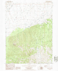
1986 Map of Cooper Peak
USGS Topo · Published 1986About this map
The Roberts Mountains dominate the southern portion of this mid-1980s landscape, rising sharply from the ranchlands of Denay Valley in Eureka County. This high-elevation terrain is characterized by an extensive network of drainage systems, including Pete Hanson Creek, Birch Creek, and Kelley Creek, which flow northward toward the valley floor. The map captures a moment in the region's mining and ranching history, noting the solitary Willow Creek Ranch and numerous unnamed prospects, mines, and a mineshaft scattered throughout the higher reaches near Cooper Peak and Western Peak. The transition from the alluvial fans of the valley to the steep slopes of Gabel Canyon highlights the area's geological complexity. Notable livestock infrastructure, such as several stock tanks and a corral, indicates the continued importance of range grazing in this remote high-desert environment.
Find a feature on this map
22 named features on this map. Tap any name to fly to it.
Don’t see what you’re looking for? This feature index may not catch every label — zoom into the map to look around manually.
Map Details
Editions of this 1986 Cooper Peak Map
This is the sole edition of this map. No revisions or reprints were ever made.
Other maps of this area

1926 · Roberts Mountains
USGS Topo · 1:250,000

1929 · Roberts Mountains
USGS Topo · 1:250,000

1937 · Mineral Hill
USGS Topo · 1:48,000

1943 · Mineral Hill
USGS Topo · 1:62,500

1949 · Garden Valley
USGS Topo · 1:62,500

1949 · Roberts Creek Mtn
USGS Topo · 1:62,500

1951 · Roberts Creek Mtn
USGS Topo · 1:62,500

1951 · Garden Valley
USGS Topo · 1:62,500

1955 · Millett
USGS Topo · 1:250,000

1955 · Winnemucca
USGS Topo · 1:250,000