
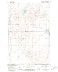
1961 Map of Cooperstown West
USGS Topo · Published 1963About this map
The western edges of Cooperstown and the surrounding prairie of Griggs County are documented in this early 1960s survey, showing a landscape defined by the intersection of rail infrastructure and glacial geology. The Northern Pacific railroad corridor serves as the primary north-south axis, connecting the main settlement with the smaller outpost of Shepard further south. This period reveals the township structures of Cooperstown, Helena, and Ball Hill, reflecting the organized agricultural settlement patterns of the North Dakota plains.
Find a feature on this map
9 named features on this map. Tap any name to fly to it.
Don’t see what you’re looking for? This feature index may not catch every label — zoom into the map to look around manually.
Map Details
Editions of this 1961 Cooperstown West Map
2 editions found
Other maps of this area

1952 · New Rockford
USGS Topo · 1:250,000

1956 · New Rockford
USGS Topo · 1:250,000

1961 · Binford
USGS Topo · 1:24,000

1961 · Cooperstown East
USGS Topo · 1:24,000

1961 · Jessie
USGS Topo · 1:24,000

1961 · Revere
USGS Topo · 1:24,000

1961 · Hannaford
USGS Topo · 1:24,000

1961 · Sutton NE
USGS Topo · 1:24,000

1961 · Karnak
USGS Topo · 1:24,000
1967 · Kloten SE
USGS Topo · 1:24,000