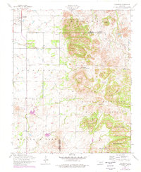
1956 Map of Cooperton
USGS Topo · Published 1976About this map
Cooperton stands as the primary settlement on the high plains of the Kiowa County and Comanche County line, marking a landscape where agricultural flats meet the dramatic granite rises of the Wichita Mountains. This mid-century survey captures a diverse terrain, from the sprawling reach of the Wichita Mountains Wildlife Refuge to the family-named landmarks of Marshall and the Saddle Mountain range. Genealogists and local historians will find significant value in the location of Springhill Cemetery and the various water sources that sustained early land use, such as Time-O-Day Spring, Buffalo Spring, and Sugar Creek Spring. The map documents the intricate drainage patterns of Otter Creek and Wichita Creek, which carve through the peaks of Grace Mountain and Mount Pinchot, providing a clear record of the area's geography before significant modern development altered the rural character of these southwestern Oklahoma townships.
Find a feature on this map
28 named features on this map. Tap any name to fly to it.
Don’t see what you’re looking for? This feature index may not catch every label — zoom into the map to look around manually.
Map Details
Editions of this 1956 Cooperton Map
2 editions found

Other maps of this area

1937 · Cache
USGS Topo · 1:48,000

1937 · Quanah Mountain
USGS Topo · 1:24,000

1942 · Cache
USGS Topo · 1:62,500

1949 · Cooperton
USGS Topo · 1:62,500

1949 · Quanah Mountain
USGS Topo · 1:24,000

1950 · Snyder
USGS Topo · 1:62,500

1950 · Saddle Mountain
USGS Topo · 1:62,500

1955 · Lawton
USGS Topo · 1:250,000

1956 · Glen Mountains
USGS Topo · 1:24,000

1956 · Saddle Mountain
USGS Topo · 1:24,000