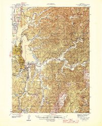
1945 Map of Coos Bay
USGS Topo · Published 1945About this map
Industrial and maritime activity along the southern Oregon coast defines this 1940s landscape. North Bend and Coos Bay serve as the primary urban hubs, surrounded by a complex network of sloughs and waterways like Catching Slough and Isthmus Slough. The region's resource-based economy is evident in the presence of the Libby Coal Mine (Inactive) and the Southport Coal Mine, while the Southern Pacific railroad and the iconic Coos Bay Bridge provide critical transportation links. Rural life is anchored by small settlements such as Glasgow, Allegany, and Sumner, many of which supported local education through facilities like the Sunny Hill Sch and Kentuck Sch. Navigation across the rivers still relied on traditional infrastructure, including the Enegren Ferry on the Coos River, capturing a moment before modern bridges fully replaced established river crossings.
Find a feature on this map
95 named features on this map. Tap any name to fly to it.
Don’t see what you’re looking for? This feature index may not catch every label — zoom into the map to look around manually.
Map Details
Editions of this 1945 Coos Bay Map
3 editions found

Other maps of this area

1896 · Coos Bay
USGS Topo · 1:125,000

1898 · Coos Bay
USGS Topo · 1:125,000

1900 · Coos Bay
USGS Topo · 1:125,000

1923 · Reedsport
USGS Topo · 1:62,500

1928 · Sitkum
USGS Topo · 1:125,000

1942 · Reedsport
USGS Topo · 1:62,500

1942 · Empire
USGS Topo · 1:62,500

1942 · Coquille
USGS Topo · 1:62,500

1942 · Coos Bay
USGS Topo · 1:62,500

1943 · Bandon
USGS Topo · 1:62,500