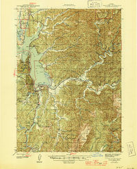
1945 Map of Coos Bay
USGS Topo · Published 1950About this map
Coos Bay and North Bend anchor this 1945 coastal survey, revealing a landscape defined by its intricate network of tidal waterways and timber-rich uplands. The Southern Pacific railroad follows the shoreline through Glasgow and across the Coos Bay Bridge, connecting the industrial waterfronts to the larger region. Inland, the extraction economy is visible through the Libby Coal Mine and Southport Coal Mine, while the timber influence is underscored by the borders of the Siuslaw National Forest and Elliott State Forest.
Find a feature on this map
95 named features on this map. Tap any name to fly to it.
Don’t see what you’re looking for? This feature index may not catch every label — zoom into the map to look around manually.
Map Details
Editions of this 1945 Coos Bay Map
3 editions found

Other maps of this area

1896 · Coos Bay
USGS Topo · 1:125,000

1898 · Coos Bay
USGS Topo · 1:125,000

1900 · Coos Bay
USGS Topo · 1:125,000

1923 · Reedsport
USGS Topo · 1:62,500

1928 · Sitkum
USGS Topo · 1:125,000

1942 · Reedsport
USGS Topo · 1:62,500

1942 · Empire
USGS Topo · 1:62,500

1942 · Coquille
USGS Topo · 1:62,500

1942 · Coos Bay
USGS Topo · 1:62,500

1943 · Bandon
USGS Topo · 1:62,500