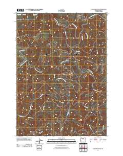
2011 Map of Coos Mountain
USGS Topo · Published 2011About this map
The South Fork Coos River winds through the northern reaches of this coastal range terrain, where the Coos River Fish Hatchery stands near the confluence with Salmon Creek. This landscape is defined by the drainage divide between two major river systems, as the southern portion of the quadrangle gives way to the headwaters of the North Fork Coquille River and its tributary, the Little North Fork Coquille River. Coos Mountain serves as a prominent landmark in the southeast, surrounded by a dense network of named drainages like Moon Creek and Hudson Creek. The presence of Rock Crusher Creek and the Coquille-Fairview Rd indicates the area's history of resource management and local transit between the Coos and Coquille river valleys. The map provides a detailed look at the intricate topography of the Southern Oregon Coast Range before these waters reach the Pacific.
Find a feature on this map
18 named features on this map. Tap any name to fly to it.
Don’t see what you’re looking for? This feature index may not catch every label — zoom into the map to look around manually.
Map Details
Editions of this 2011 Coos Mountain Map
This is the sole edition of this map. No revisions or reprints were ever made.
Other maps of this area

1896 · Coos Bay
USGS Topo · 1:125,000

1898 · Coos Bay
USGS Topo · 1:125,000

1900 · Coos Bay
USGS Topo · 1:125,000

1928 · Sitkum
USGS Topo · 1:125,000

1942 · Coquille
USGS Topo · 1:62,500

1942 · Coos Bay
USGS Topo · 1:62,500

1945 · Coquille
USGS Topo · 1:62,500

1945 · Coos Bay
USGS Topo · 1:62,500

1954 · Coos Bay
USGS Topo · 1:250,000

1955 · Ivers Peak
USGS Topo · 1:62,500