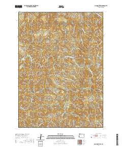
2020 Map of Coos Mountain
USGS Topo · Published 2020About this map
Coos Mtn serves as the central anchor for this deeply dissected landscape in the Coast Range of Coos County. The drainage patterns here are complex, defined by the divide between the South Fork Coos River system to the north and the N Fork Coquille River headwaters to the south. Significant logging and access routes are visible, including the Coquille Fairview Rd and Fork Ridge Rd, which navigate the steep contours between drainages such as Salmon Cr and Rock Crusher Cr. This 2020 survey demonstrates the intersection of the region's historical timber-driven geography and its intricate hydrography, featuring smaller tributaries like Moon Cr and Little N Fork Coquille River. The presence of Moon Creek Rd provides a clear look at how human infrastructure follows the natural corridors carved by water through these dense hills.
Find a feature on this map
25 named features on this map. Tap any name to fly to it.
Don’t see what you’re looking for? This feature index may not catch every label — zoom into the map to look around manually.
Map Details
Editions of this 2020 Coos Mountain Map
This is the sole edition of this map. No revisions or reprints were ever made.
Other maps of this area

1896 · Coos Bay
USGS Topo · 1:125,000

1898 · Coos Bay
USGS Topo · 1:125,000

1900 · Coos Bay
USGS Topo · 1:125,000

1928 · Sitkum
USGS Topo · 1:125,000

1942 · Coquille
USGS Topo · 1:62,500

1942 · Coos Bay
USGS Topo · 1:62,500

1945 · Coquille
USGS Topo · 1:62,500

1945 · Coos Bay
USGS Topo · 1:62,500

1954 · Coos Bay
USGS Topo · 1:250,000

1955 · Ivers Peak
USGS Topo · 1:62,500