
1956 Map of Copalis Crossing
USGS Topo · Published 1959About this map
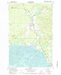
The Humptulips River meanders toward North Bay in this mid-century portrait of coastal Grays Harbor County, revealing a landscape defined by tidelands and timber-era infrastructure. The Northern Pacific railroad serves as the region's backbone, connecting small settlements like Copalis Crossing, Wilderness, and Tulips along its route. The presence of several Cranberry Bogs near Saddle Hill and Kurtz Slough points to the specialized agriculture that took root in the low-lying wet soils behind the coast. Along the river, numerous Slough systems including Jessie Slough and Campbell Slough weave through a terrain marked by prominent heights like Langley Hill. The map documents the intricate transition from riverine woods to the expansive Tidal Flat at the bay's edge, where navigational markers like Piling and named channels like East Channel and Grass Creek Channel guided local watercraft through the mud and silt.
Find a feature on this map
32 named features on this map. Tap any name to fly to it.
Don’t see what you’re looking for? This feature index may not catch every label — zoom into the map to look around manually.
Map Details
Editions of this 1956 Copalis Crossing Map
4 editions found

Other maps of this area

1938 · Moclips
USGS Topo · 1:62,500

1941 · Moclips
USGS Topo · 1:62,500

1941 · Grayland
USGS Topo · 1:62,500

1943 · Humptulips
USGS Topo · 1:62,500

1943 · Copalis Beach
USGS Topo · 1:250,000

1951 · Copalis Beach
USGS Topo · 1:250,000

1953 · Hoquiam
USGS Topo · 1:250,000

1955 · Humptulips
USGS Topo · 1:62,500

1955 · Point Brown
USGS Topo · 1:24,000

1955 · Carlisle
USGS Topo · 1:24,000