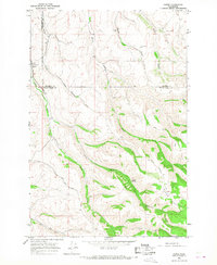
1966 Map of Coppei
USGS Topo · Published 1967About this map
The Northern Pacific railroad cuts through the northwestern corner of this landscape, serving the small settlement of Coppei during the mid-1960s. The area is defined by a dense network of watercourses and canyons, where Coppei Creek splits into its North Fork and South Fork. These deep drainages create a rugged agricultural environment where local infrastructure, such as the Storage Bins Grain Elevator, stands alongside natural landmarks like Coppei Springs.
Find a feature on this map
24 named features on this map. Tap any name to fly to it.
Don’t see what you’re looking for? This feature index may not catch every label — zoom into the map to look around manually.
Map Details
Editions of this 1966 Coppei Map
2 editions found
Other maps of this area

1919 · Walla Walla
USGS Topo · 1:125,000

1921 · Walla Walla
USGS Topo · 1:125,000

1937 · Pomeroy
USGS Topo · 1:96,000

1942 · Pomeroy
USGS Topo · 1:125,000

1953 · Walla Walla
USGS Topo · 1:250,000

1955 · Pullman
USGS Topo · 1:250,000

1958 · Pullman
USGS Topo · 1:250,000

1958 · Walla Walla
USGS Topo · 1:250,000

1966 · Dixie
USGS Topo · 1:24,000
1966 · Buroker
USGS Topo · 1:24,000