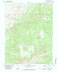
1983 Map of Copper Globe
USGS Topo · Published 1983About this map
Copper Globe and the surrounding high desert of Emery County appear here as they were documented in the mid-1970s. The landscape is defined by a complex network of canyons and washes, including the deep cuts of Devils Canyon, Eagle Canyon, and Reds Canyon. This topography provided the backdrop for a history of mineral exploration, evidenced by several extractive sites scattered across the flats. The Copper Globe Mine sits prominently near Sagebrush Bench, while the Lucky Strike Mine is located further south near Spring. Remote infrastructure is visible in the form of a Landing Strip and numerous Jeep Trails that traverse Justensen Flats and Link Flats. These routes connect isolated landmarks like Square Top and the geological formation known as The Dike, illustrating how prospectors and ranchers navigated this arid terrain before more modern developments.
Find a feature on this map
24 named features on this map. Tap any name to fly to it.
Don’t see what you’re looking for? This feature index may not catch every label — zoom into the map to look around manually.
Map Details
Editions of this 1983 Copper Globe Map
2 editions found
Other maps of this area

1885 · San Rafael
USGS Topo · 1:250,000

1885 · Fish Lake
USGS Topo · 1:250,000

1896 · Fish Lake
USGS Topo · 1:250,000

1952 · Wild Horse
USGS Topo · 1:62,500

1952 · San Rafael Knob
USGS Topo · 1:62,500

1953 · Stinking Spring Creek 2 SE
USGS Topo · 1:24,000

1953 · Emery 4 NE
USGS Topo · 1:24,000

1953 · Emery 1 NE
USGS Topo · 1:24,000

1953 · Emery 1 SE
USGS Topo · 1:24,000

1954 · Stinking Spring Creek 3 NW
USGS Topo · 1:24,000