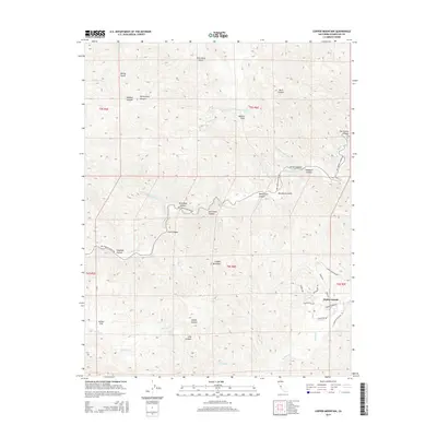
2015 Map of Copper Mountain
USGS Topo · Published 2015About this map
Diablo Grande sits at the eastern edge of this landscape, marking a transition from the rugged canyons to more modern residential development along Diablo Grande Pky and Panoz Rd. The central terrain is defined by Copper Mountain and a complex network of seasonal drainages, including Del Puerto Cr and Salado Cr. This 2015 survey reveals an area where old ranching and natural landmarks like Ballard Flat and Adobe Flat persist alongside newer road networks. Historically named water sources such as Salt Grass Springs and Fellows Spring are noted deep within the canyons, providing a detailed look at the hydrology of the Diablo Range. The presence of colorfully named terrain features like Murderers Gulch, Blind Mans Gulch, and Slick Rock Canyon suggests a long history of local lore and early exploration in these foothills.
Find a feature on this map
43 named features on this map. Tap any name to fly to it.
Don’t see what you’re looking for? This feature index may not catch every label — zoom into the map to look around manually.
Map Details
Editions of this 2015 Copper Mountain Map
This is the sole edition of this map. No revisions or reprints were ever made.
Other maps of this area

1913 · Romain
USGS Topo · 1:31,680

1915 · Westley
USGS Topo · 1:31,680

1916 · Patterson
USGS Topo · 1:31,680

1916 · Romain
USGS Topo · 1:31,680

1919 · Orestimba
USGS Topo · 1:62,500

1919 · Orestimba Creek
USGS Topo · 1:31,680

1922 · Carbona
USGS Topo · 1:62,500

1938 · Mt. Boardman
USGS Topo · 1:62,500

1941 · Orestimba
USGS Topo · 1:62,500
1941 · Modesto West
USGS Topo · 1:62,500