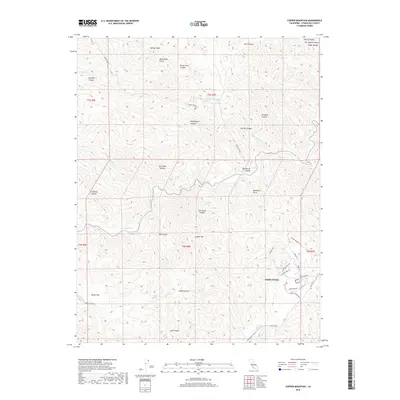
2018 Map of Copper Mountain
USGS Topo · Published 2018About this map
Diablo Grande sits in the southeast corner of this terrain, marking a pocket of development within the varied canyon lands of the Diablo Range. The landscape is defined by an intricate network of drainages and peaks, including the prominent Copper Mtn and the steep walls of Del Puerto Canyon. This 2018 survey reveals a topography where water sources such as Fellows Spring and Salt Grass Springs have historically dictated movement and land use. The presence of descriptively named features like Murderers Gulch, Blind Mans Gulch, and Slick Rock Canyon suggests a storied local history of prospecting or ranching. High-elevation roads such as Mount Oso Rd and Adobe Canyon Rd provide access to the interior, connecting the lower flats like Adobe Flat with the higher ridges that divide Stanislaus County.
Find a feature on this map
47 named features on this map. Tap any name to fly to it.
Don’t see what you’re looking for? This feature index may not catch every label — zoom into the map to look around manually.
Map Details
Editions of this 2018 Copper Mountain Map
This is the sole edition of this map. No revisions or reprints were ever made.
Other maps of this area

1913 · Romain
USGS Topo · 1:31,680

1915 · Westley
USGS Topo · 1:31,680

1916 · Patterson
USGS Topo · 1:31,680

1916 · Romain
USGS Topo · 1:31,680

1919 · Orestimba
USGS Topo · 1:62,500

1919 · Orestimba Creek
USGS Topo · 1:31,680

1922 · Carbona
USGS Topo · 1:62,500

1938 · Mt. Boardman
USGS Topo · 1:62,500

1941 · Orestimba
USGS Topo · 1:62,500
1941 · Modesto West
USGS Topo · 1:62,500