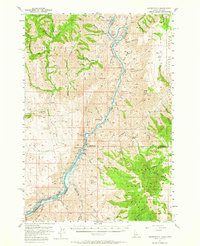
1957 Map of Copperfield
USGS Topo · Published 1965About this map
The Snake River defines the canyon landscape of this mid-century survey, marking the border between Idaho and Oregon. At the northern end, the settlement of Copperfield and the Oxbow Sch sit near a sharp bend in the river, while the Baker-Homestead Highway traces the western bank. A significant detail is the blue hatching along the river corridor, indicating the vast areas slated to be submerged by the impending Brownlee Dam. This transition is further evidenced by the presence of the Brownlee Sch and the Gaging Sta along the water's edge. To the east, the terrain rises sharply toward Cuddy Mountain within the Payette National Forest, while the western slopes are part of the Whitman National Forest. Local landmarks like Wildhorse Falls and the Microwave Relay Station provide specific points of reference in this high-relief environment.
Find a feature on this map
52 named features on this map. Tap any name to fly to it.
Don’t see what you’re looking for? This feature index may not catch every label — zoom into the map to look around manually.
Map Details
Editions of this 1957 Copperfield Map
3 editions found
Other maps of this area

1915 · Pine
USGS Topo · 1:125,000

1920 · Seven Devils Mining District
USGS Topo · 1:48,000

1954 · Cornucopia
USGS Topo · 1:62,500

1955 · Baker
USGS Topo · 1:250,000

1955 · Grangeville
USGS Topo · 1:250,000

1957 · Halfway
USGS Topo · 1:62,500

1957 · Cambridge
USGS Topo · 1:62,500

1957 · Cuprum
USGS Topo · 1:62,500

1957 · Homestead
USGS Topo · 1:62,500

1957 · Copperfield
USGS Topo · 1:62,500