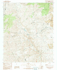
1989 Map of Copperplate Gulch
USGS Topo · Published 1990About this map
Coronado Mine and the encroaching edge of the Morenci Pit anchor this late 20th-century landscape of extraction along the Graham and Greenlee county line. The map captures a rugged transition where industrial operations meet the natural boundaries of the Apache National Forest and the San Carlos Indian Reservation. Water management is central to this environment, evidenced by the aqueduct, pipeline, and various water tanks serving the mining district. Deep drainages like Eagle Creek and Copperplate Gulch carve through the terrain, while the settlement at Trujillo and an Old Railroad Grade hint at earlier layers of human activity. The presence of Hot Springs and numerous prospects throughout the gulches illustrates the complex geothermal and mineral character of the region during this period of geological survey.
Find a feature on this map
40 named features on this map. Tap any name to fly to it.
Don’t see what you’re looking for? This feature index may not catch every label — zoom into the map to look around manually.
Map Details
Editions of this 1989 Copperplate Gulch Map
This is the sole edition of this map. No revisions or reprints were ever made.
Other maps of this area

1902 · Clifton
USGS Topo · 1:62,500

1913 · Morenci
USGS Topo · 1:125,000

1915 · Morenci
USGS Topo · 1:125,000

1954 · Silver City
USGS Topo · 1:250,000

1954 · Clifton
USGS Topo · 1:250,000

1957 · Clifton
USGS Topo · 1:250,000

1958 · Silver City
USGS Topo · 1:250,000

1958 · Clifton
USGS Topo · 1:250,000

1960 · Guthrie
USGS Topo · 1:62,500

1960 · Safford
USGS Topo · 1:62,500