
Loading...
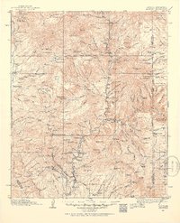
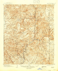
Loading map...1913 Map of Morenci
USGS Topo · Published 1954About this map
The mining hubs of Morenci and Clifton anchor the southern portion of this landscape, reflecting the industrial gravity of the copper district just before the First World War. The copper-rich terrain is marked by prominent peaks such as Copper King Mtn and Markeen Mtn, with the Arizona and New Mexico railroad providing the vital connection to the outside world. North of the industrial center, the land transitions into the high country of the Apache National Forest, where the economy shifted toward timber and ranching.
Find a feature on this map
188 named features on this map. Tap any name to fly to it.
Don’t see what you’re looking for? This feature index may not catch every label — zoom into the map to look around manually.
Map Details
Date Portrayed1913
Date Published1954
PublisherU.S. Geological Survey
Map TypeTopographic
Scale1:125,000
Physical Dimensions17 x 20.8 inches
Editions of this 1913 Morenci Map
2 editions found
Historical Maps of Clifton Through Time
Featured Locations
Source Details
SourceU.S. Geological Survey
CopyrightPublic Domain