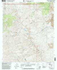
1997 Map of Copperplate Gulch
USGS Topo · Published 2000About this map
Coronado Mountain and the surrounding high desert of eastern Arizona dominate this landscape, where industrial mining and cattle ranching have left their mark. The eastern edge of the survey reveals the massive scale of the Morenci Pit (Open Pit Mine), contrasting with the rugged canyons and isolated outposts like Trujillo and Seneca Corral. Water management is central to this arid region, evidenced by the Eagle Creek Pumping Station and several Gaging Stations along Eagle Creek. This terrain sits at a significant cultural and administrative junction, straddling the boundary between the Apache National Forest and the San Carlos Indian Reservation. Numerous Mine Shafts and the historic Coronado Mine signify the area's long-standing reliance on copper and mineral extraction, while natural features like Hot Springs and Bat Cave punctuate the deep drainages of Hot Springs Canyon.
Find a feature on this map
39 named features on this map. Tap any name to fly to it.
Don’t see what you’re looking for? This feature index may not catch every label — zoom into the map to look around manually.
Map Details
Editions of this 1997 Copperplate Gulch Map
This is the sole edition of this map. No revisions or reprints were ever made.
Other maps of this area

1902 · Clifton
USGS Topo · 1:62,500

1913 · Morenci
USGS Topo · 1:125,000

1915 · Morenci
USGS Topo · 1:125,000

1954 · Silver City
USGS Topo · 1:250,000

1954 · Clifton
USGS Topo · 1:250,000

1957 · Clifton
USGS Topo · 1:250,000

1958 · Silver City
USGS Topo · 1:250,000

1958 · Clifton
USGS Topo · 1:250,000

1960 · Guthrie
USGS Topo · 1:62,500

1960 · Safford
USGS Topo · 1:62,500