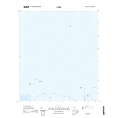
2020 Map of Coquille Point
USGS Topo · Published 2020About this map
Battledore Reef and the fragile marshes of the Mississippi River Delta characterize this maritime landscape in Plaquemines Parish. The map documents a shifting environment where the waters of Quarantine Bay and Grand Bay meet narrow strips of land. Notable landforms such as Sable Island and Raccoon Point illustrate the fragmented nature of the coastal shelf as it transitions into the Gulf. The presence of Fort Bayou and Bayou Plaquemines indicates the complex network of tidal channels that define this region. This survey serves as a vital record of the Louisiana coastline, showing the precise locations of named features like Coquille Point and Deepwater Point amidst the vast aquatic reaches of Little Coquille Bay and Grand Coquille Bay.
Find a feature on this map
17 named features on this map. Tap any name to fly to it.
Don’t see what you’re looking for? This feature index may not catch every label — zoom into the map to look around manually.
Map Details
Editions of this 2020 Coquille Point Map
This is the sole edition of this map. No revisions or reprints were ever made.
Other maps of this area

1892 · Quarantine
USGS Topo · 1:62,500

1893 · La Fortuna
USGS Topo · 1:62,500

1893 · Forts
USGS Topo · 1:62,500

1893 · Dime
USGS Topo · 1:62,500

1935 · Taylor Pass
USGS Topo · 1:31,680

1935 · Tropical Bend
USGS Topo · 1:31,680

1941 · Black Bay
USGS Topo · 1:62,500

1941 · Empire
USGS Topo · 1:62,500
1944 · Black Bay
USGS Topo · 1:62,500

1944 · Empire
USGS Topo · 1:62,500