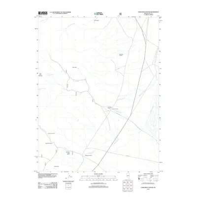
2012 Map of Corcoran Canyon
USGS Topo · Published 2012About this map
Stone House Ranch and Meadow Creek Ranch stand as primary points of habitation in this high-desert region of Nye County. The landscape is defined by a complex network of seasonal drainages and springs, including Corcoran Divide Spring and Little Table Mountain Spring, which were vital for sustaining the remote ranching operations. The topography is marked by significant elevation changes, from the flat expanse of Meadow Creek Bench to prominent landmarks like Tooth Rock and the high ridges of Little Table Mountain. Deep incisions in the earth such as Corcoran Canyon, Toll Canyon, and Ryecroft Canyon follow the paths of Corcoran Creek and Meadow Creek, illustrating the erosive forces that have shaped this portion of the Nevada interior. The presence of NFD 445 RD and NFD 005 RD indicates the modern infrastructure used to navigate these traditional grazing lands.
Find a feature on this map
20 named features on this map. Tap any name to fly to it.
Don’t see what you’re looking for? This feature index may not catch every label — zoom into the map to look around manually.
Map Details
Editions of this 2012 Corcoran Canyon Map
This is the sole edition of this map. No revisions or reprints were ever made.
Other maps of this area

1956 · Tonopah
USGS Topo · 1:250,000

1959 · Tonopah
USGS Topo · 1:250,000

1962 · Tonopah
USGS Topo · 1:250,000

1971 · Belmont East
USGS Topo · 1:24,000

1971 · Corcoran Canyon
USGS Topo · 1:24,000

1971 · Barley Creek
USGS Topo · 1:24,000
1971 · Elkhorn Canyon
USGS Topo · 1:24,000

1971 · Mosquito Creek
USGS Topo · 1:24,000

1971 · Belmont West
USGS Topo · 1:24,000

1971 · Jefferson
USGS Topo · 1:24,000