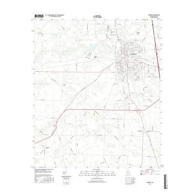
2017 Map of Cordele
USGS Topo · Published 2017About this map
The city of Cordele serves as the focal point of this 2017 survey, showing a grid of numbered avenues and streets that transition into the agricultural landscapes of Crisp County. To the west and south, the terrain is defined by a network of waterways including Gum Creek, Cedar Creek, and Gully Creek, which feed into local landmarks such as Byrds Millpond and Williams Lake. The map provides significant genealogical value through its documentation of numerous burial sites, from larger municipal locations like Westview Cem and Sunnyside Cem to more secluded spots like Slade Cem and Whitsett Cem. Smaller outlying settlements like Wenona and Raines are clearly marked, illustrating the distribution of populations across the rural areas surrounding the main town. The inclusion of Evergreen Memorial Gardens and Bethel Cem further highlights the community's established history.
Find a feature on this map
157 named features on this map. Tap any name to fly to it.
Don’t see what you’re looking for? This feature index may not catch every label — zoom into the map to look around manually.
Map Details
Editions of this 2017 Cordele Map
This is the sole edition of this map. No revisions or reprints were ever made.
Other maps of this area

1953 · Waycross
USGS Topo · 1:250,000

1957 · Macon
USGS Topo · 1:250,000

1958 · Macon
USGS Topo · 1:250,000

1958 · Waycross
USGS Topo · 1:250,000

1964 · Macon
USGS Topo · 1:250,000

1971 · Pineview SW
USGS Topo · 1:24,000

1972 · Drayton
USGS Topo · 1:24,000
1972 · Vienna
USGS Topo · 1:24,000
1974 · Cordele
USGS Topo · 1:24,000
1977 · Cobb
USGS Topo · 1:24,000