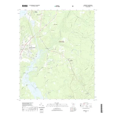
2020 Map of Cordesville
USGS Topo · Published 2020About this map
The Francis Marion National Forest dominates this landscape of low-lying wetlands and historic watercourses in Berkeley County. The area is defined by the legacy of the low country's agricultural past, evidenced by the clustered burial grounds including Lewisfield Plantation Cem, Exeter Plantation Cem, and Ghachan Plantation Cem. Water management is a primary feature, shown through the modern Tailrace Canal and the remnants of the Old Santee Canal near the town of Moncks Corner. Further south, the West Branch Cooper River and its tributaries like Mepkin Cr snake through a terrain of swamps and bays, including the distinct Vanilla Bay. Modern settlements such as Cordesville and Santee Circle are connected by a network of rural roads that cross major waterways at landmarks like Wadboo Bridge and Mepkin Bridge.
Find a feature on this map
88 named features on this map. Tap any name to fly to it.
Don’t see what you’re looking for? This feature index may not catch every label — zoom into the map to look around manually.
Map Details
Editions of this 2020 Cordesville Map
This is the sole edition of this map. No revisions or reprints were ever made.
Other maps of this area

1919 · Summerville
USGS Topo · 1:48,000

1919 · Cordesville
USGS Topo · 1:48,000

1920 · Chicora
USGS Topo · 1:48,000

1920 · Summerville
USGS Topo · 1:62,500

1921 · Chicora
USGS Topo · 1:62,500

1943 · Chicora
USGS Topo · 1:62,500

1943 · Bonneau
USGS Topo · 1:62,500

1944 · Summerville
USGS Topo · 1:62,500

1948 · Cordesville
USGS Topo · 1:24,000

1948 · Bethera
USGS Topo · 1:24,000