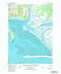
1950 Map of Cordova A-1
USGS Topo · Published 1984About this map
The Don Miller Hills rise above a landscape dominated by the complex delta systems and tidal flats of the Gulf of Alaska in this mid-century survey. The confluence of the Bering River and the Nichawak River creates a labyrinthine network of channels and sloughs, including Puffy Slough, that feed into the vast expanse of Mud within Controller Bay. This area represents a wilderness environment where early industrial attempts are marked by a solitary Cannery near Chilkat and scattered Cabins near Jessie Creek.
Find a feature on this map
43 named features on this map. Tap any name to fly to it.
Don’t see what you’re looking for? This feature index may not catch every label — zoom into the map to look around manually.
Map Details
Editions of this 1950 Cordova A-1 Map
4 editions found
Other maps of this area

1948 · Cordova
USGS Topo · 1:250,000

1948 · Middleton Island
USGS Topo · 1:250,000

1950 · Middleton Island
USGS Topo · 1:250,000

1950 · Bering Glacier
USGS Topo · 1:250,000

1950 · Icy Bay
USGS Topo · 1:250,000

1950 · Cordova B-2
USGS Topo · 1:63,360

1950 · Cordova A-1
USGS Topo · 1:63,360

1950 · Cordova A-2
USGS Topo · 1:63,360

1951 · Icy Bay
USGS Topo · 1:250,000

1951 · Bering Glacier
USGS Topo · 1:250,000