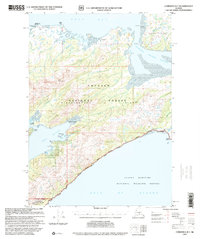
1997 Map of Cordova B-7
USGS Topo · Published 2000About this map
Hinchinbrook Island and the southern tip of Hawkins Island dominate this coastal landscape, where the waters of Orca Bay meet the Gulf of Alaska. The interior of the Chugach National Forest is accessible only by remote outposts like the Double Bay Cabin (FS) and Hook Point Cabin (FS), highlighting the area's isolation and reliance on maritime or aerial access. Aviation and maritime safety infrastructure are concentrated at Johnstone Point, featuring the Johnstone Light, a Landing Strip, and technical facilities such as a Vortac Station (FAA) and Communication Tower.
Find a feature on this map
58 named features on this map. Tap any name to fly to it.
Don’t see what you’re looking for? This feature index may not catch every label — zoom into the map to look around manually.
Map Details
Editions of this 1997 Cordova B-7 Map
This is the sole edition of this map. No revisions or reprints were ever made.
Other maps of this area

1948 · Cordova
USGS Topo · 1:250,000

1950 · Cordova C-7
USGS Topo · 1:63,360

1950 · Cordova C-6
USGS Topo · 1:63,360

1950 · Cordova B-7
USGS Topo · 1:63,360

1950 · Cordova C-8
USGS Topo · 1:63,360

1951 · Cordova
USGS Topo · 1:250,000

1951 · Cordova B-8
USGS Topo · 1:63,360
1951 · Cordova A-7 and A-8
USGS Topo · 1:63,360

1951 · Cordova B-6
USGS Topo · 1:63,360

1952 · Cordova C-8
USGS Topo · 1:63,360