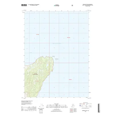
2018 Map of Cordova B-8 SW
USGS Topo · Published 2018About this map
Chugach National Forest encompasses the land on this coastal Alaskan quadrangle, revealing the intersection of dense coastal timber and the tidal reaches of Prince William Sound. The terrain is defined by the sharp transition from the water at Zaikof Bay to the rising interior elevations, where topographical contours trace the shoreline’s edge. Notable maritime landmarks include Zaikof Point and the offshore Schooner Rock, which serve as critical navigational references for this maritime environment. This modern survey reflects the permanence of the federally protected wilderness, showing no human settlements or roads, and instead focusing on the hydrological and topographical reality of the Montague Island area. The lack of development emphasizes the region's character as a preserved coastal ecosystem within the national forest system.
Find a feature on this map
9 named features on this map. Tap any name to fly to it.
Don’t see what you’re looking for? This feature index may not catch every label — zoom into the map to look around manually.
Map Details
Editions of this 2018 Cordova B-8 SW Map
This is the sole edition of this map. No revisions or reprints were ever made.
Other maps of this area

1948 · Cordova
USGS Topo · 1:250,000

1951 · Seward
USGS Topo · 1:250,000

1951 · Cordova
USGS Topo · 1:250,000

1951 · Seward B-1
USGS Topo · 1:63,360

1951 · Seward A-1
USGS Topo · 1:63,360

1951 · Cordova B-8
USGS Topo · 1:63,360
1951 · Cordova A-7 and A-8
USGS Topo · 1:63,360

1952 · Seward B-1
USGS Topo · 1:63,360

1953 · Seward A-1
USGS Topo · 1:63,360
1953 · Cordova B-8
USGS Topo · 1:63,360