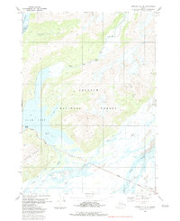
1983 Map of Cordova C-5 SE
USGS Topo · Published 1983About this map
The Chugach National Forest landscape east of Orca Inlet is defined by an intricate network of glacial runoff and tidal sloughs. The Copper River Highway serves as the primary terrestrial artery, crossing several major water systems including the Eyak River and Ibeck River. This 1983 survey illustrates a complex hydrological environment where freshwater sources like Eyak Lake meet the saltwater influence of the inlet. Notable landmarks include Boy Scout Island and Mavis Island, which sit near the river mouth, and a Gaging Sta located along a Pack Trail near Power Creek. The terrain transitions from the high peaks of the Heney Range and the cascading Ohman Falls down to the braided channels of Eyak Slough and Currin Slough, reflecting the dynamic coastal geography of the region.
Find a feature on this map
25 named features on this map. Tap any name to fly to it.
Don’t see what you’re looking for? This feature index may not catch every label — zoom into the map to look around manually.
Map Details
Editions of this 1983 Cordova C-5 SE Map
This is the sole edition of this map. No revisions or reprints were ever made.
Other maps of this area

1948 · Cordova
USGS Topo · 1:250,000

1950 · Cordova C-4
USGS Topo · 1:63,360

1951 · Cordova
USGS Topo · 1:250,000

1951 · Cordova B-4
USGS Topo · 1:63,360

1951 · Cordova C-5
USGS Topo · 1:63,360

1951 · Cordova B-5
USGS Topo · 1:63,360

1953 · Cordova B-5
USGS Topo · 1:63,360

1953 · Cordova C-4
USGS Topo · 1:63,360

1953 · Cordova C-5
USGS Topo · 1:63,360

1959 · Cordova
USGS Topo · 1:250,000