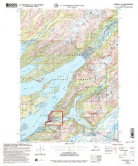
2000 Map of Cordova C-5
USGS Topo · Published 2003About this map
Cordova serves as the focal point of this coastal landscape, situated between the tidal waters of Orca Inlet and the freshwater expanse of Eyak Lake. The town's layout is defined by the steep rise of Mount Eyak and Tripod Hill, which hem in the settlement against the shoreline of Orca Bay. To the south, the Copper River Highway traces the edge of the Heney Range, passing the Cordova Municipal Airport and providing access to the expansive Copper River Delta Fish and Wildlife Management Area.
Find a feature on this map
60 named features on this map. Tap any name to fly to it.
Don’t see what you’re looking for? This feature index may not catch every label — zoom into the map to look around manually.
Map Details
Editions of this 2000 Cordova C-5 Map
This is the sole edition of this map. No revisions or reprints were ever made.
Other maps of this area

1948 · Cordova
USGS Topo · 1:250,000

1950 · Cordova C-6
USGS Topo · 1:63,360

1950 · Cordova C-4
USGS Topo · 1:63,360

1950 · Cordova D-5
USGS Topo · 1:63,360

1951 · Cordova
USGS Topo · 1:250,000

1951 · Cordova B-4
USGS Topo · 1:63,360

1951 · Cordova C-5
USGS Topo · 1:63,360

1951 · Cordova B-5
USGS Topo · 1:63,360

1951 · Cordova D-6
USGS Topo · 1:63,360

1951 · Cordova D-4
USGS Topo · 1:63,360