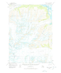
1950 Map of Cordova D-3
USGS Topo · Published 1978About this map
The Copper River flows through the eastern edge of this 1950 survey, marking a distinct boundary between the waterway and the massive glacial systems of the Chugach Mountains. The landscape is dominated by ice, featuring the expansive Schwan Glacier in the northwest and the Allen Glacier sprawling across the southern portion. This area highlights a dynamic glacial environment at mid-century, where the McCune Glacier and Shiels Glacier converge. Smaller features like Island Pt and Ginny Creek provide rare fixed points of reference amidst the shifting ice fields and numerous crevasses that define the high-altitude terrain. The map captures the raw geographical state of this remote region before the minor administrative revisions of the late 1970s.
Find a feature on this map
10 named features on this map. Tap any name to fly to it.
Don’t see what you’re looking for? This feature index may not catch every label — zoom into the map to look around manually.
Map Details
Editions of this 1950 Cordova D-3 Map
2 editions found
Other maps of this area

1948 · Cordova
USGS Topo · 1:250,000

1950 · Valdez A-3
USGS Topo · 1:63,360

1950 · Cordova C-4
USGS Topo · 1:63,360

1950 · Cordova D-3
USGS Topo · 1:63,360

1951 · Cordova
USGS Topo · 1:250,000

1951 · Cordova C-3
USGS Topo · 1:63,360

1951 · Cordova D-4
USGS Topo · 1:63,360

1951 · Valdez A-2
USGS Topo · 1:63,360

1952 · Valdez
USGS Topo · 1:250,000

1953 · Cordova D-4
USGS Topo · 1:63,360