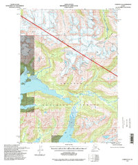
1994 Map of Cordova D-6
USGS Topo · Published 1998About this map
Chugach National Forest land dominates this coastal quadrangle, where the deep glacial inlets of Port Fidalgo and Port Gravina carve into the Alaskan mainland. Compiled from topography established in the mid-20th century and updated with imagery from the early 1990s, the map reveals a wilderness landscape defined by significant elevation changes, from sea level at Beartrap Bay to the 6,422-foot summit of Meteorite Mtn. The intricate drainage systems are clearly marked, including the West Fork Olsen Bay Creek and East Fork Olsen Bay Creek which converge at Olsen Bay. Notable for the total absence of roads or trails, the area relies on water access at points such as Whalen Bay and Spill. This survey serves as a precise record of the shoreline and maritime geography before subsequent coastal shifts, illustrating the proximity of steep peaks like those surrounding Browns Basin to the saltwater estuaries.
Find a feature on this map
18 named features on this map. Tap any name to fly to it.
Don’t see what you’re looking for? This feature index may not catch every label — zoom into the map to look around manually.
Map Details
Editions of this 1994 Cordova D-6 Map
This is the sole edition of this map. No revisions or reprints were ever made.
Other maps of this area

1948 · Cordova
USGS Topo · 1:250,000

1950 · Cordova C-7
USGS Topo · 1:63,360

1950 · Cordova C-6
USGS Topo · 1:63,360

1950 · Cordova D-7
USGS Topo · 1:63,360

1950 · Cordova D-5
USGS Topo · 1:63,360

1951 · Cordova
USGS Topo · 1:250,000

1951 · Cordova C-5
USGS Topo · 1:63,360

1951 · Cordova D-6
USGS Topo · 1:63,360

1951 · Valdez A-6
USGS Topo · 1:63,360

1952 · Valdez
USGS Topo · 1:250,000