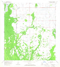
1958 Map of Corkscrew SE
USGS Topo · Published 1966About this map
Corkscrew Swamp Sanctuary anchors the northwest corner of this 1950s study, revealing the complex hydrology of the northern Everglades before extensive modern drainage. The landscape is a mosaic of cypress strands and higher ground, most notably the broad expanse of Big Corkscrew Island. The terrain is characterized by elongated wetlands like Horsepen Strand and Winchester Strand, which channel water through the limestone and sand of southern Florida. Evidence of human attempts to manage this water is found in several Flowing Wells and a straight-line grid of unimproved dirt roads that segment the interior. The presence of Bird Rookery Swamp and the Shaggy Cypress Swamp illustrates the dense, water-dependent ecosystems that historically defined this part of the interior peninsula.
Find a feature on this map
13 named features on this map. Tap any name to fly to it.
Don’t see what you’re looking for? This feature index may not catch every label — zoom into the map to look around manually.
Map Details
Editions of this 1958 Corkscrew SE Map
3 editions found
Other maps of this area

1956 · West Palm Beach
USGS Topo · 1:250,000

1957 · West Palm Beach
USGS Topo · 1:250,000

1958 · West Palm Beach
USGS Topo · 1:250,000

1958 · Corkscrew SE
USGS Topo · 1:24,000

1958 · Corkscrew NW
USGS Topo · 1:24,000

1958 · Catherine Island
USGS Topo · 1:24,000

1958 · Immokalee
USGS Topo · 1:24,000

1958 · Belle Meade NE
USGS Topo · 1:24,000

1958 · Belle Meade NW
USGS Topo · 1:24,000

1958 · Immokalee SW
USGS Topo · 1:24,000