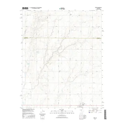
2016 Map of Corn
USGS Topo · Published 2016About this map
The town of Corn anchors the southern portion of this Washita County landscape, where the local street grid including Washington Ave and E Main St meets the rural section lines of the Oklahoma plains. This area is defined by a dense network of intermittent watercourses and small reservoirs, such as Bear Creek Site 101 Reservoir and Bear Creek Site 102 Reservoir, which feed into larger systems like the Washita River. The distribution of burial sites across the township, including Bergthal Cem and Zion Cem, reflects the early settlement patterns and community centers of the region. The terrain is deeply etched by various drainages such as Coffee Creek, Gyp Creek, and Corn Creek, illustrating the complex local hydrology that dictates the agricultural layout of the surrounding prairies.
Find a feature on this map
28 named features on this map. Tap any name to fly to it.
Don’t see what you’re looking for? This feature index may not catch every label — zoom into the map to look around manually.
Map Details
Editions of this 2016 Corn Map
This is the sole edition of this map. No revisions or reprints were ever made.
Other maps of this area

1955 · Clinton
USGS Topo · 1:250,000

1956 · Cordell
USGS Topo · 1:62,500

1957 · Clinton
USGS Topo · 1:250,000

1957 · Clinton
USGS Topo · 1:62,500

1961 · Eakly
USGS Topo · 1:62,500

1964 · Weatherford
USGS Topo · 1:62,500

1976 · Clinton SE
USGS Topo · 1:24,000

1976 · Clinton SW
USGS Topo · 1:24,000
1983 · Bessie
USGS Topo · 1:24,000
1983 · Clinton
USGS Topo · 1:24,000