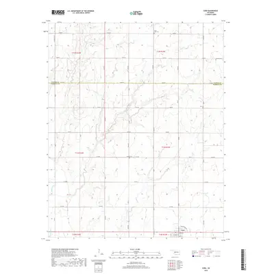
2018 Map of Corn
USGS Topo · Published 2018About this map
The town of Corn anchors the southeastern corner of this Oklahoma landscape, situated where the grid of Washington Ave and W Lincoln Ave meets the prairie. This region in the early 21st century remains defined by its agricultural layout, with a dense network of section-line roads like E1070 Rd and NS 234 crossing the terrain. The map reveals the critical importance of local watercourses, including Corn Cr and Coffee Cr, which drain toward the Washita River in the southwest. For family historians, the presence of several distinct burial grounds such as Berghthal Cem, Zion Cem, and Krimmer Cem suggests a history of diverse community settlements scattered across the Custer and Washita county line.
Find a feature on this map
45 named features on this map. Tap any name to fly to it.
Don’t see what you’re looking for? This feature index may not catch every label — zoom into the map to look around manually.
Map Details
Editions of this 2018 Corn Map
This is the sole edition of this map. No revisions or reprints were ever made.
Other maps of this area

1955 · Clinton
USGS Topo · 1:250,000

1956 · Cordell
USGS Topo · 1:62,500

1957 · Clinton
USGS Topo · 1:250,000

1957 · Clinton
USGS Topo · 1:62,500

1961 · Eakly
USGS Topo · 1:62,500

1964 · Weatherford
USGS Topo · 1:62,500

1976 · Clinton SE
USGS Topo · 1:24,000

1976 · Clinton SW
USGS Topo · 1:24,000
1983 · Bessie
USGS Topo · 1:24,000
1983 · Clinton
USGS Topo · 1:24,000