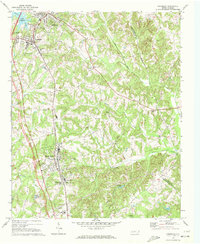
1970 Map of Cornelius
USGS Topo · Published 1972About this map
Davidson College anchors the northern reaches of this Mecklenburg County landscape, just as the newly formed Lake Norman begins to reshape the western horizon. The 1970 field check captures a period of transition where traditional agrarian patterns and small rail-oriented towns like Cornelius and Huntersville meet the infrastructure of modern growth. The Southern railroad line remains a central spine for the communities of Caldwell and Smithville, while a network of regional pipelines and facilities such as the Mecklenburg Sanatorium and a State Prison mark the shifting land use. Numerous country churches and burial grounds, including Hopewell Ch, Ramah Ch, and Bethel Cem, provide essential landmarks for genealogists tracing family locations across the drainage basins of the South Prong Rocky River and Torrence Creek.
Find a feature on this map
37 named features on this map. Tap any name to fly to it.
Don’t see what you’re looking for? This feature index may not catch every label — zoom into the map to look around manually.
Map Details
Editions of this 1970 Cornelius Map
2 editions found
Other maps of this area

1893 · Statesville
USGS Topo · 1:125,000

1941 · Charlotte
USGS Topo · 1:125,000

1942 · Charlotte
USGS Topo · 1:125,000

1948 · Paw Creek
USGS Topo · 1:24,000

1948 · Derita
USGS Topo · 1:24,000

1949 · Kannapolis
USGS Topo · 1:24,000

1949 · Harrisburg
USGS Topo · 1:24,000

1949 · Hicks Crossroads
USGS Topo · 1:24,000

1953 · Charlotte
USGS Topo · 1:250,000

1954 · Charlotte
USGS Topo · 1:250,000