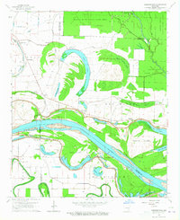
1964 Map of Cornerstone
USGS Topo · Published 1965About this map
Arkansas River meanders through the heart of this landscape, carving out a complex network of oxbow lakes and islands along the border of Jefferson and Lincoln counties. The terrain is defined by its relation to the river, featuring substantial landforms like Huffs Island and Cooper Island, protected by a prominent Levee system. This mid-century survey captures a rural agricultural and hunting region punctuated by small settlements like Cornerstone and Sweden. The map provides significant genealogical value, documenting numerous community landmarks including Morning Star Church, Union Church, and Kinnlen Star Church, alongside family-named burial sites such as Brent Cemetery and Nickelson Cemetery. To the north, the Bayou Meto State Game Area preserves the bottomland character of the Little Bayou Meto drainage, while features like Swan Lake and Round Cypress Brake illustrate the region's ancient hydrological history.
Find a feature on this map
48 named features on this map. Tap any name to fly to it.
Don’t see what you’re looking for? This feature index may not catch every label — zoom into the map to look around manually.
Map Details
Editions of this 1964 Cornerstone Map
2 editions found
Other maps of this area

1935 · Altheimer
USGS Topo · 1:62,500

1935 · Varner
USGS Topo · 1:62,500

1935 · Noble Lake
USGS Topo · 1:62,500

1941 · Goldman
USGS Topo · 1:62,500

1948 · Helena
USGS Topo · 1:250,000

1950 · Helena
USGS Topo · 1:250,000

1955 · Helena
USGS Topo · 1:250,000

1959 · Helena
USGS Topo · 1:250,000

1960 · Helena
USGS Topo · 1:250,000
1964 · Cades
USGS Topo · 1:24,000