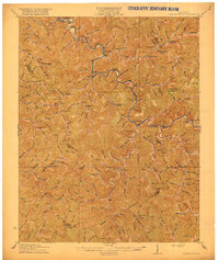
1916 Map of Cornettsville
USGS Topo · Published 1916About this map
The Lexington & Eastern RR winds through the Kentucky River valley during this era of early twentieth-century development, anchoring the regional economy between Hazard and the Ulvah Sta. depot. The landscape is defined by its deep vertical relief, where a dense network of mountain hollows and ridges like Sassafras Ridge dictate the placement of small communities and schools. Dozens of locally numbered educational sites, including Trace Fork School and Redoak School, appear in the watersheds of Davidson Cr and Buffalo Cr, reflecting the dispersed settlement pattern of the period.
Find a feature on this map
177 named features on this map. Tap any name to fly to it.
Don’t see what you’re looking for? This feature index may not catch every label — zoom into the map to look around manually.
Map Details
Editions of this 1916 Cornettsville Map
3 editions found


Other maps of this area

1887 · Jonesville
USGS Topo · 1:125,000

1890 · Whitesburg
USGS Topo · 1:125,000

1891 · Hazard
USGS Topo · 1:125,000

1891 · Jonesville
USGS Topo · 1:125,000

1892 · Whitesburg
USGS Topo · 1:125,000

1894 · Estillville
USGS Topo · 1:125,000

1903 · Harlan
USGS Topo · 1:48,000

1912 · Hindman
USGS Topo · 1:48,000

1913 · Oven Fork
USGS Topo · 1:48,000

1913 · Buckhorn
USGS Topo · 1:62,500