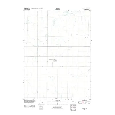
2011 Map of Cornlea
USGS Topo · Published 2011About this map
Cornlea serves as the primary hub of this eastern Nebraska landscape, characterized by a well-organized grid of section roads and several winding watercourses. The local community center is anchored by the Cornlea Post Office and the nearby Sacred Heart Cemetery, providing important markers for genealogists and local historians. To the south, the Moriah Cemetery sits alone along the section lines, further indicating the historical footprint of early settlements in the region.
Find a feature on this map
27 named features on this map. Tap any name to fly to it.
Don’t see what you’re looking for? This feature index may not catch every label — zoom into the map to look around manually.
Map Details
Editions of this 2011 Cornlea Map
This is the sole edition of this map. No revisions or reprints were ever made.
Other maps of this area

1955 · Fremont
USGS Topo · 1:250,000

1957 · Fremont
USGS Topo · 1:250,000

1958 · Fremont
USGS Topo · 1:250,000

1963 · Madison
USGS Topo · 1:24,000

1963 · Battle Creek SE
USGS Topo · 1:24,000

1963 · Battle Creek SW
USGS Topo · 1:24,000

1966 · Tarnov
USGS Topo · 1:24,000
1966 · Lindsay SW
USGS Topo · 1:24,000

1966 · Platte Center
USGS Topo · 1:24,000
1966 · Lindsay
USGS Topo · 1:24,000