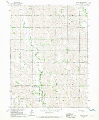
1966 Map of Lindsay SW
USGS Topo · Published 1967About this map
The Old Indian Treaty Boundary cuts across the southern portion of this landscape, marking a historical divide between Platte and Nance Counties. This rural expanse in the mid-1960s is defined by its watercourses, including Shell Creek, Lost Creek, and the winding Looking Glass Creek. The settlement pattern is anchored by a dense network of country schools and churches, reflecting a close-knit agricultural community. Notable landmarks for genealogical research include the Bethany Ch Cem and West Hill Cem, alongside several parish centers like Palestine Ch and St Pauls Ch. The presence of numbered school districts, such as School No 26 and School No 39, alongside named facilities like Postville Sch, highlights the local commitment to education during this era of Nebraska’s development.
Find a feature on this map
21 named features on this map. Tap any name to fly to it.
Don’t see what you’re looking for? This feature index may not catch every label — zoom into the map to look around manually.
Map Details
Editions of this 1966 Lindsay SW Map
2 editions found
Other maps of this area

1896 · Stromsburg
USGS Topo · 1:125,000

1955 · Fremont
USGS Topo · 1:250,000

1957 · Fremont
USGS Topo · 1:250,000

1958 · Fremont
USGS Topo · 1:250,000

1958 · Genoa
USGS Topo · 1:24,000

1958 · Monroe
USGS Topo · 1:24,000

1958 · Fullerton NE
USGS Topo · 1:24,000

1958 · St. Edward
USGS Topo · 1:24,000
1966 · Newman Grove
USGS Topo · 1:24,000

1966 · Tarnov
USGS Topo · 1:24,000