
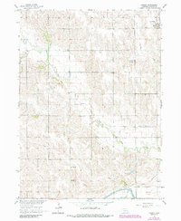
1966 Map of Tarnov
USGS Topo · Published 1967About this map
Tarnov serves as the primary hub in this mid-1960s Platte County landscape, situated along the Union Pacific line in the northeast corner of the sheet. The area is characterized by a dense network of rural infrastructure, including numerous educational and religious centers such as Wattsville Sch and Postville Ch. The mapping of townships like Joliet, Burrows, and Monroe reveals a grid of section lines dotted with family and parish landmarks, including St Michaels Cem and Greenwood Cem. Drainage patterns are defined by the winding courses of Shell Creek and Lost Creek, which move through the agricultural heartland. In the south, the engineering of the Loup River Canal and its associated Siphon illustrates the mid-century water management systems essential to the region's productivity and development.
Find a feature on this map
22 named features on this map. Tap any name to fly to it.
Don’t see what you’re looking for? This feature index may not catch every label — zoom into the map to look around manually.
Map Details
Editions of this 1966 Tarnov Map
2 editions found
Other maps of this area

1896 · Stromsburg
USGS Topo · 1:125,000

1899 · David City
USGS Topo · 1:125,000

1955 · Fremont
USGS Topo · 1:250,000

1957 · Fremont
USGS Topo · 1:250,000

1958 · Fremont
USGS Topo · 1:250,000

1958 · Genoa
USGS Topo · 1:24,000

1958 · Monroe
USGS Topo · 1:24,000

1958 · Duncan
USGS Topo · 1:24,000
1966 · Lindsay SW
USGS Topo · 1:24,000

1966 · Platte Center
USGS Topo · 1:24,000