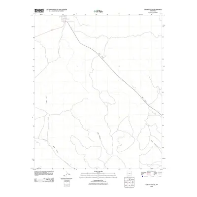
2010 Map of Corona South
USGS Topo · Published 2010About this map
Corona sits at the northern edge of this high-altitude landscape, serving as a primary point of human activity amidst a network of natural drainage systems. The terrain is defined by its deep arroyos and canyons, including the extensive path of Gallo Canyon which cuts diagonally across the northeastern quadrant. To the south and west, the topography is carved by Bonita Canyon, Dark Canyon, and Mesa Canyon, illustrating the erosional patterns typical of the Lincoln County high country. Transportation in this early 21st-century period relies on a sparse grid of rural routes such as County Rd-A031 and County Rd-A033, which provide access to the remote canyon floors and elevated mesas that dominate the region south of the settlement.
Find a feature on this map
11 named features on this map. Tap any name to fly to it.
Don’t see what you’re looking for? This feature index may not catch every label — zoom into the map to look around manually.
Map Details
Editions of this 2010 Corona South Map
This is the sole edition of this map. No revisions or reprints were ever made.
Other maps of this area

1954 · Fort Sumner
USGS Topo · 1:250,000

1958 · Fort Sumner
USGS Topo · 1:250,000

1980 · Corona
USGS Topo · 1:100,000

1981 · Gallo Spring Canyon
USGS Topo · 1:24,000

1981 · Rough Mountain
USGS Topo · 1:24,000

1981 · Camaleon Draw West
USGS Topo · 1:24,000
1981 · Tecolote Peak
USGS Topo · 1:24,000
1981 · Pelon Hill
USGS Topo · 1:24,000

1981 · Corona South
USGS Topo · 1:24,000
1981 · Corona North
USGS Topo · 1:24,000