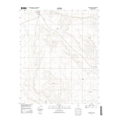
2013 Map of Corona South
USGS Topo · Published 2013About this map
The high plains and arroyos of central New Mexico define the landscape around Corona, where the town’s grid is centered near the intersection of Main St and DuBoise Ave. This 2013 topographic survey illustrates the transition from the high-desert plateau into a series of significant drainage systems that carve through the terrain south of the settlement. Water management in this arid environment is evidenced by features like Simpson Tank, while the natural topography is dominated by the expansive Gallo Canyon and Mesa Canyon. Roads such as NM-247 and Us-54 N provide the primary transit corridors through the area, with smaller arteries like Co Road A031 leading toward the deeper reaches of Bonita Canyon. The map provides a precise view of the local land divisions and the varied relief of the southern Lincoln County territory.
Find a feature on this map
17 named features on this map. Tap any name to fly to it.
Don’t see what you’re looking for? This feature index may not catch every label — zoom into the map to look around manually.
Map Details
Editions of this 2013 Corona South Map
This is the sole edition of this map. No revisions or reprints were ever made.
Other maps of this area

1954 · Fort Sumner
USGS Topo · 1:250,000

1958 · Fort Sumner
USGS Topo · 1:250,000

1980 · Corona
USGS Topo · 1:100,000

1981 · Gallo Spring Canyon
USGS Topo · 1:24,000

1981 · Rough Mountain
USGS Topo · 1:24,000

1981 · Camaleon Draw West
USGS Topo · 1:24,000
1981 · Tecolote Peak
USGS Topo · 1:24,000
1981 · Pelon Hill
USGS Topo · 1:24,000

1981 · Corona South
USGS Topo · 1:24,000
1981 · Corona North
USGS Topo · 1:24,000