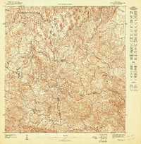
1947 Map of Corozal NE
USGS Topo · Published 1947About this map
The rugged interior of Puerto Rico’s north-central region is defined by the winding course of the Río La Plata and the deep valleys carved by the Mavilla and Prieto rivers. During the early 1940s, this landscape was characterized by a dense network of mountain trails and scattered rural dwellings, connected by essential social hubs like the Escuela Segunda Unidad Quebrada Arenas and the Escuela Segunda Unidad de Palmarejo. The map reveals the intricate municipal borders where the Municipio de Toa Alta, Municipio de Corozal, and Municipio de Naranjito meet. This topographical study emphasizes the agricultural and residential patterns of the era, where life followed the contours of the Quebrada and Cañas waterways before modern development altered the rural character of the highland municipalities.
Find a feature on this map
11 named features on this map. Tap any name to fly to it.
Don’t see what you’re looking for? This feature index may not catch every label — zoom into the map to look around manually.
Map Details
Editions of this 1947 Corozal NE Map
This is the sole edition of this map. No revisions or reprints were ever made.
Other maps of this area

1940 · Vega Alta
USGS Topo · 1:30,000

1941 · Bayamon
USGS Topo · 1:30,000

1946 · Corozal
USGS Topo · 1:30,000

1946 · Vega Alta
USGS Topo · 1:30,000

1946 · Naranjito
USGS Topo · 1:30,000

1947 · Corozal SO
USGS Topo · 1:10,000
1947 · Naranjito SO
USGS Topo · 1:10,000

1947 · Corozal NO
USGS Topo · 1:10,000

1947 · Bayamon
USGS Topo · 1:30,000
1947 · Naranjito NO
USGS Topo · 1:10,000
Featured Places
- Sunflower Valley, Toa Alta
- Reparto Pérez, Toa Alta
- Las Villas, Toa Alta
- Sector Rabo del Buey, Toa Alta
- Sector Las Colinas, Toa Alta