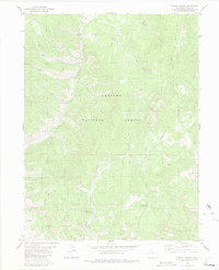
1980 Map of Corral Peaks
USGS Topo · Published 1984About this map
Arapaho National Forest defines this high-elevation landscape in Grand County, where drainage networks converge at the East Fork Troublesome Creek. The map documents a rugged interior accessible primarily by a network of historic routes, including the Hay Park Trail (Pack), Pack Trail, and various Jeep Trails. Human activity is concentrated around isolated outposts such as East Fork Cow Camp and the Wheatley Ranch at Wheatley Bend.
Find a feature on this map
32 named features on this map. Tap any name to fly to it.
Don’t see what you’re looking for? This feature index may not catch every label — zoom into the map to look around manually.
Map Details
Editions of this 1980 Corral Peaks Map
2 editions found
Other maps of this area

1954 · Craig
USGS Topo · 1:250,000

1956 · Radial Mountain
USGS Topo · 1:24,000

1956 · Kremmling
USGS Topo · 1:62,500

1956 · Parkview Mountain
USGS Topo · 1:24,000

1956 · Hyannis Peak
USGS Topo · 1:24,000

1956 · Hyannis Peak
USGS Topo · 1:62,500

1956 · Rand
USGS Topo · 1:62,500

1957 · Craig
USGS Topo · 1:250,000

1957 · Hot Sulphur Springs
USGS Topo · 1:62,500

1958 · Craig
USGS Topo · 1:250,000