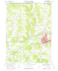
1968 Map of Corry
USGS Topo · Published 1975About this map
The industrial and transportation hub of Corry anchors this late 1960s survey, showing the city's complex rail network where the Penn Central and Erie-Lackawanna lines converge. The landscape is a mix of urban density and rural Pennsylvania forest, with the northern boundary following the New York Pennsylvania state line. Significant institutional landmarks are visible throughout the city, including the Corry Area High Sch, Hosp, and St Edwards Sch, while the outskirts are marked by resource management and recreation sites like the State Fish Hatchery and State Game Lands No 154.
Find a feature on this map
72 named features on this map. Tap any name to fly to it.
Don’t see what you’re looking for? This feature index may not catch every label — zoom into the map to look around manually.
Map Details
Editions of this 1968 Corry Map
3 editions found
Other maps of this area

1905 · Clymer
USGS Topo · 1:62,500

1913 · North East
USGS Topo · 1:62,500

1915 · North East
USGS Topo · 1:62,500

1929 · Corry
USGS Topo · 1:48,000

1929 · Union City
USGS Topo · 1:62,500

1932 · Corry
USGS Topo · 1:62,500

1932 · Union City
USGS Topo · 1:62,500

1939 · Clymer
USGS Topo · 1:62,500

1941 · Clymer
USGS Topo · 1:62,500

1943 · North East
USGS Topo · 1:62,500