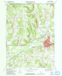
1968 Map of Corry
USGS Topo · Published 1993About this map
The city of Corry serves as a concentrated industrial and transportation hub where the Penn Central and Erie-Lackawanna railroads intersect. This 1968 landscape is defined by its transition from the dense urban grid of Corry to the managed wilderness of State Game Lands No 154 along the New York state line. The map captures a period of specialized land use, featuring the State Fish Hatchery and the Lawrence Airport, while the surrounding countryside is dotted with legacy family-named locations such as Mertz Corners and Wheelock. To the south, the South Branch French Creek winds through Concord township, an area marked by small rural nodes like Elgin and Lovell. Local genealogy is well-represented through numerous church and cemetery sites, including Pine Grove Cem and St Thomas Cem, which anchor the historical footprint of Erie County families.
Find a feature on this map
69 named features on this map. Tap any name to fly to it.
Don’t see what you’re looking for? This feature index may not catch every label — zoom into the map to look around manually.
Map Details
Editions of this 1968 Corry Map
3 editions found
Other maps of this area

1905 · Clymer
USGS Topo · 1:62,500

1913 · North East
USGS Topo · 1:62,500

1915 · North East
USGS Topo · 1:62,500

1929 · Corry
USGS Topo · 1:48,000

1929 · Union City
USGS Topo · 1:62,500

1932 · Corry
USGS Topo · 1:62,500

1932 · Union City
USGS Topo · 1:62,500

1939 · Clymer
USGS Topo · 1:62,500

1941 · Clymer
USGS Topo · 1:62,500

1943 · North East
USGS Topo · 1:62,500