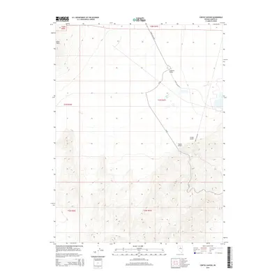
2014 Map of Cortez Canyon
USGS Topo · Published 2014About this map
Crescent Valley dominates the northern landscape of this Nevada terrain, where the wide basin meets the rising contours of the mountain ranges. The drainage of Cooks Cr flows through the center of the sheet, providing a hydrological artery for this arid region. To the south, the topography grows increasingly complex as the map climbs toward Cortez Canyon and the notable indentation of Copper Canyon. Transportation in this area is defined by the winding path of Cortez Canyon Rd and Cr-222, which trace the natural passages between the peaks. In the northwest, the prominent landmark of Squaw Butte serves as a distinct navigational point overlooking the valley floor. This 2014 survey captures the traditional land divisions of the Public Land Survey System, including t27n r47e and t26n r47e, reflecting the enduring legal framework of the American West.
Find a feature on this map
13 named features on this map. Tap any name to fly to it.
Don’t see what you’re looking for? This feature index may not catch every label — zoom into the map to look around manually.
Map Details
Editions of this 2014 Cortez Canyon Map
This is the sole edition of this map. No revisions or reprints were ever made.
Other maps of this area

1938 · Cortez
USGS Topo · 1:48,000

1944 · Cortez
USGS Topo · 1:62,500

1949 · Crescent Valley
USGS Topo · 1:62,500

1949 · Mt. Lewis
USGS Topo · 1:62,500

1950 · Mt. Lewis
USGS Topo · 1:62,500

1950 · Crescent Valley
USGS Topo · 1:62,500

1955 · Winnemucca
USGS Topo · 1:250,000

1958 · Winnemucca
USGS Topo · 1:250,000

1962 · Winnemucca
USGS Topo · 1:250,000

1962 · Carico Lake
USGS Topo · 1:62,500