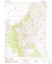
1986 Map of Cortez
USGS Topo · Published 1986About this map
Cortez Mountains and the Toiyabe Range dominate this mid-1980s landscape at the border of Lander and Eureka counties. The settlement of Cortez sits at the base of Mt Tenabo, serving as a focal point for an area defined by extensive mineral extraction. The map reveals a complex industrial footprint, including the Cortez Mine, an Open Pit, and significant Tailings deposits.
Find a feature on this map
20 named features on this map. Tap any name to fly to it.
Don’t see what you’re looking for? This feature index may not catch every label — zoom into the map to look around manually.
Map Details
Editions of this 1986 Cortez Map
This is the sole edition of this map. No revisions or reprints were ever made.
Other maps of this area

1938 · Cortez
USGS Topo · 1:48,000

1944 · Cortez
USGS Topo · 1:62,500

1949 · Crescent Valley
USGS Topo · 1:62,500

1950 · Crescent Valley
USGS Topo · 1:62,500

1955 · Winnemucca
USGS Topo · 1:250,000

1957 · Frenchie Creek
USGS Topo · 1:62,500

1957 · Horse Creek Valley
USGS Topo · 1:62,500

1958 · Winnemucca
USGS Topo · 1:250,000

1962 · Winnemucca
USGS Topo · 1:250,000
1985 · Hand-Me-Down Creek
USGS Topo · 1:24,000